N.B: Please excuse my terrible attempt at a map, scanned from the bushwalking book; clearly a bit of a fail as the two parts don't connect, but you get the idea... For a better copy, ask me for the book.
After overshooting the start, we found ourselves wandering down Young St, with spectacular view of Cockatoo Island/Parramatta River, and rather amusingly, bumped into another family clutching a copy of the same bushwalking guide, just finishing the walk (having done it starting from the other end); we didn’t ask them how the walk was, choosing to adopting the maxim ‘ignorance is bliss’.
At this rather advanced stage in the walk (read: outset), a toilet stop was needed but although the local toilets were adorned with the most whimsical graffiti, they were less than whimsical within, so it was decided we could wait, which as it turned out was for the best, as the architect-designed toilet block at Ballast Point park was a Wonder of the Modern World by comparison.
A tale of two toilets
We took the opportunity to admire the views of Cockatoo Island from the park at the end of the point, mentally bookmarking it as an excellent picnicking spot for future food-laden trips, before threading our way along a rocky path, past the unconventional Dawn Fraser swimming pool (I think she actually lives in Balmain, which is fitting), brushing aside overhanging branches.
Willows obscuring the Dawn Fraser Swimming Pool (photo credit: 52 suburbs)
We then followed the trail past yacht moorings, latticed Federation homes with minimalist Christmas decorations (e.g. few sparse twigs bent into a wreath shape painted silver) and mini Coopers galore. At the end of Louisa Rd is Birchgrove Wharf and Yurulbin Park but being lazy sods we cut this part out of the walk, instead making a Beeline across Birchgrove Park (possibly the most scenic place in Sydney for a cricket or football game; it surely helps local mums and dads summon up enthusiasm to go watch their kids play Saturday sports).
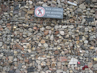
The next point of interest was Ballast Point Park; formerly a Caltex oil depot and now beautifully designed Public Park (cleverly referencing its industrial heritage). Here I will direct you to a few stunning pictures taken by the lady from 52 suburbs, and then my own curious photo, which if anyone has an explanation for it, I would be very interested to hear it.
The walk then loops around Mort Bay. For a maritime/history tragic like myself, this was a complete boon, Mort Bay being the place where ferries and tugs are moored and serviced (and go to die, I presume?), and is fringed by old factory buildings that have been converted to covetable apartments blocks (e.g. the Palmolive building).
 |
| Palmolive Buildings & Ferry/Tug Graveyards |
After some increasing desperate strides on the part of my family, we emerged back on Darling St, at the eastern end, where the street dives steeply down towards East Balmain wharf. The view is quite the salve to any pain that might have built up from walking so far, and the sun-drenched park at the end (yes the sun came out, although only for a while), perfect for loitering in whilst waiting for a normal breathing pattern to resume.
Here a sane person might catch a bus back to the shops and cafes, rather than brave the hill and several kilometres between themselves and their car, or even catch a ferry if they were so clever as to have planned that far ahead. Rest assured, we did not take the sane option and I won’t bore you with details of my complaining (somewhat stifled by an ice-cream pit-stop). When we eventually reached the car 30 mins later, we were all thoroughly exhausted but satisfied at having experienced a more intrepid and invigorating day-after-the-day-after-Christmas day than normal.


3 comments:
Ballast Point Park so happened to be one of my precedents for two projects completed in subjects last year! The $11m project has been the result of collaboration between master planners and a few architects including ones from firm McGregor Coxall and Choi Ropiha.
In answer to your question, your textural photo depicts the curious gabion walls that cage in remnants of site demolition. If you look closely (or have good eyes) you can find artifacts from the past and the occasional anachronistic item (probably the whims and follies of construction workers, attracted to the idea of forever marking a site).
The padlocks reflect Sydney-lovers that wish to mark their eternal love for one another, apparently an Italian tradition. Closer up you can see the engravings of names - countless couples that have put locks on the walls and thrown keys into the sea as a symbol of everlasting love. At least this sappiness looks beautiful for once.
Also the orange strips of fabric that cast moving shadows are in fact recycled seat belts/safety strapping! A clever little move by Ropiha.
Louis you are fabulous!
I never dreamt that anyone would come up with an explanation nevermind one as comprehensive yet romantic as that!
Thankyou, I wish we'd had you as a guide when we were wandering around; I'm sure there were so many ingenuous features we ignorantly dismissed as piles of rubble or whatever.
Wow - just checked out your blog for the first time in a long while...nice to see you guys are still alive and posting :P (epic posts, CL)
Post a Comment